![](/images/other/stat-length.png)
![Randonnée A pied El Paso - SL LP 107 San Nicolás-Hoyo de La Sima - Photo](https://media.geolcdn.com/t/1900/400/0a641edc-7dd6-4778-b34a-8a54cdd14265.jpeg&format=pjpeg&maxdim=2)
SL LP 107 San Nicolás-Hoyo de La Sima
SityTrail - itinéraires balisés pédestres
Tous les sentiers balisés d’Europe GUIDE+
![Longueur](/images/other/stat-length.png)
Longueur
3,2 km
![Altitude max](https://static1.geolcdn.com/siteimages/upload/files/1508320355ic_sort_altitude_max_24dp.png)
Altitude max
1233 m
![Dénivelé positif](https://static1.geolcdn.com/siteimages/upload/files/1508320355ic_sort_den_pos_24dp.png)
Dénivelé positif
0 m
![Km-Effort](/images/other/stat-length.png)
Km-Effort
5,2 km
![Altitude min](https://static1.geolcdn.com/siteimages/upload/files/1508320355ic_sort_altitude_min_24dp.png)
Altitude min
616 m
![Dénivelé négatif](https://static1.geolcdn.com/siteimages/upload/files/1508320355ic_sort_den_neg_24dp.png)
Dénivelé négatif
608 m
![Boucle](https://static1.geolcdn.com/siteimages/upload/files/16400158638029165_repeat_loop_refresh_sync_direction_icon.png)
Boucle
Non
Balise
Date de création :
2022-02-14 14:24:16.249
Dernière modification :
2022-02-14 14:24:16.249
![A pied](https://static1.geolcdn.com/sitytour/trail-icons/100.png)
1h11
Difficulté : Facile
![Scannez ce code QR pour ouvrir la randonnée dans l'application SityTrail](https://capi.geolives.com/qq0zvz2zws4bq2lad0pu/sitytour/trails/3108461/qr.png?size=200)
Application GPS de randonnée GRATUITE
À propos
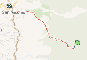
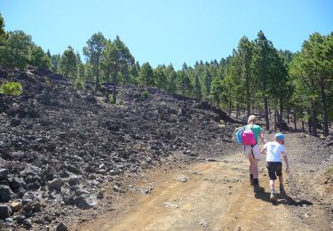
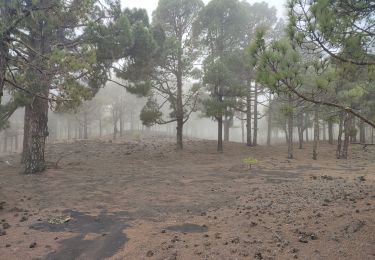
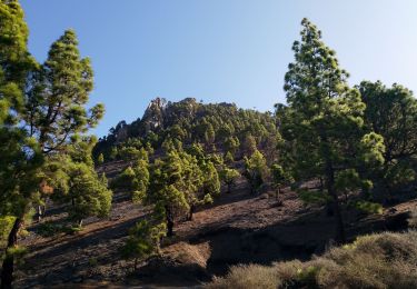
Randonnée A pied de 3,2 km à découvrir à Îles Canaries, Santa Cruz de Ténérife, El Paso. Cette randonnée est proposée par SityTrail - itinéraires balisés pédestres.
Description
Randonnée créée par Cabildo Insular de La Palma.
Symbole: parallel horizontal bars green white
Localisation
Pays :
Espagne
Région :
Îles Canaries
Département/Province :
Santa Cruz de Ténérife
Commune :
El Paso
Localité :
Unknown
Départ:(Dec)
Départ:(UTM)
220373 ; 3165945 (28R) N.
Commentaires
Randonnées à proximité
![Randonnée A pied El Paso - SL LP 105 Coladas de San Juan-Camino Barquito - Photo](https://media.geolcdn.com/t/375/260/2abdaf06-fcdc-4aac-8c3a-03e25c71a2e6.jpeg&format=jpg&maxdim=2)
![A pied A pied](https://static1.geolcdn.com/sitytour/trail-icons/100.png)
SL LP 105 Coladas de San Juan-Camino Barquito
A pied
Facile
El Paso,
Îles Canaries,
Santa Cruz de Ténérife,
Espagne
![](/images/other/stat-length.png)
3,4 km | 5 km-effort
1h 8min
![](https://static1.geolcdn.com/siteimages/upload/files/16400158638029165_repeat_loop_refresh_sync_direction_icon.png)
Non
![Randonnée A pied El Paso - SL LP 103 Coladas de San Juan-Llano de Jable - Photo](https://media.geolcdn.com/t/375/260/4ced803e-2e30-46cb-a168-37a82f9e2e6e.jpeg&format=jpg&maxdim=2)
![A pied A pied](https://static1.geolcdn.com/sitytour/trail-icons/100.png)
SL LP 103 Coladas de San Juan-Llano de Jable
A pied
Facile
El Paso,
Îles Canaries,
Santa Cruz de Ténérife,
Espagne
![](/images/other/stat-length.png)
4 km | 5,3 km-effort
1h 12min
![](https://static1.geolcdn.com/siteimages/upload/files/16400158638029165_repeat_loop_refresh_sync_direction_icon.png)
Non
![Randonnée A pied Villa de Mazo - SL VM 125 Llano de las Moscas-Pico Nambroque - Photo](https://media.geolcdn.com/t/375/260/035e1071-d6b2-4733-81f7-8ff6efada3c3.jpeg&format=jpg&maxdim=2)
![A pied A pied](https://static1.geolcdn.com/sitytour/trail-icons/100.png)
SL VM 125 Llano de las Moscas-Pico Nambroque
A pied
Facile
Villa de Mazo,
Îles Canaries,
Santa Cruz de Ténérife,
Espagne
![](/images/other/stat-length.png)
4,5 km | 6,2 km-effort
1h 24min
![](https://static1.geolcdn.com/siteimages/upload/files/16400158638029165_repeat_loop_refresh_sync_direction_icon.png)
Non
![Marche Marche](https://static1.geolcdn.com/sitytour/trail-icons/101.png)
Wikiloc La Palma: Cumbre Vieja Vulkaanroute 50% (PVDB)
Marche
Très difficile
El Paso,
Îles Canaries,
Santa Cruz de Ténérife,
Espagne
![](/images/other/stat-length.png)
13,8 km | 24 km-effort
9h 1min
![](https://static1.geolcdn.com/siteimages/upload/files/16400158638029165_repeat_loop_refresh_sync_direction_icon.png)
Oui
![Randonnée Marche El Paso - dag 3 La Palma - Photo](https://media.geolcdn.com/t/375/260/1fa39298-6499-4e59-abbd-f3560317dead.jpg&format=jpg&maxdim=2)
![Marche Marche](https://static1.geolcdn.com/sitytour/trail-icons/101.png)
dag 3 La Palma
Marche
Très difficile
El Paso,
Îles Canaries,
Santa Cruz de Ténérife,
Espagne
![](/images/other/stat-length.png)
19,4 km | 31 km-effort
4h 38min
![](https://static1.geolcdn.com/siteimages/upload/files/16400158638029165_repeat_loop_refresh_sync_direction_icon.png)
Non
![Randonnée Marche El Paso - Jedey - Photo](https://media.geolcdn.com/t/375/260/e1c10452-275b-4bbb-be52-a04219d4fbfd.jpg&format=jpg&maxdim=2)
![Marche Marche](https://static1.geolcdn.com/sitytour/trail-icons/101.png)
Jedey
Marche
Moyen
El Paso,
Îles Canaries,
Santa Cruz de Ténérife,
Espagne
![](/images/other/stat-length.png)
9,2 km | 15,8 km-effort
3h 18min
![](https://static1.geolcdn.com/siteimages/upload/files/16400158638029165_repeat_loop_refresh_sync_direction_icon.png)
Non
![Randonnée Marche El Paso - LSG El ruta de los volcanes - Photo](https://media.geolcdn.com/t/375/260/ext.jpg?maxdim=2&url=https%3A%2F%2Fservices.sitytrail.com%2FGeolivesWS%2FDownloadMedia.ashx%3FTrailID%3D792008%26Media%3D20170718131707.jpg)
![Marche Marche](https://static1.geolcdn.com/sitytour/trail-icons/101.png)
LSG El ruta de los volcanes
Marche
Moyen
El Paso,
Îles Canaries,
Santa Cruz de Ténérife,
Espagne
![](/images/other/stat-length.png)
19 km | 31 km-effort
7h 18min
![](https://static1.geolcdn.com/siteimages/upload/files/16400158638029165_repeat_loop_refresh_sync_direction_icon.png)
Non
![Randonnée Marche El Paso - Canaries - La palma - Route des Volcans - jour 3 - Photo](https://media.geolcdn.com/t/375/260/ext.jpg?maxdim=2&url=https%3A%2F%2Fstatic1.geolcdn.com%2Fsiteimages%2Fupload%2Ffiles%2F1553511878bg_sport_marche.png)
![Marche Marche](https://static1.geolcdn.com/sitytour/trail-icons/101.png)
Canaries - La palma - Route des Volcans - jour 3
Marche
Moyen
El Paso,
Îles Canaries,
Santa Cruz de Ténérife,
Espagne
![](/images/other/stat-length.png)
17,7 km | 29 km-effort
7h 44min
![](https://static1.geolcdn.com/siteimages/upload/files/16400158638029165_repeat_loop_refresh_sync_direction_icon.png)
Non
![Randonnée Marche El Paso - La Palma-Route des Volcans-PR18 - Photo](https://media.geolcdn.com/t/375/260/ext.jpg?maxdim=2&url=https%3A%2F%2Fstatic1.geolcdn.com%2Fsiteimages%2Fupload%2Ffiles%2F1553511878bg_sport_marche.png)
![Marche Marche](https://static1.geolcdn.com/sitytour/trail-icons/101.png)
La Palma-Route des Volcans-PR18
Marche
Moyen
El Paso,
Îles Canaries,
Santa Cruz de Ténérife,
Espagne
![](/images/other/stat-length.png)
15,9 km | 27 km-effort
5h 8min
![](https://static1.geolcdn.com/siteimages/upload/files/16400158638029165_repeat_loop_refresh_sync_direction_icon.png)
Oui